This article outlines the online checks about your property you can complete in order to confirm if it is large enough to be subdivided.
1. Check the zoning and planning overlay controls
Visit the Victorian government data information website and type the property address into the search bar. Click on the planning PDF icon pictured below.

This report will provide you a map of your property and show you the zone and overlay controls affecting the land. Typically your property will be in either the Residential growth zone, residential growth zone or neighbourhood residential zone. The residential growth zone is planned to accommodate the majority of growth in housing and density. The general residential zone is planned to accommodate moderate increases in density and changes to the neighbourhood character. The Neighbourhood Residential zone is expected to see very moderate increases in density or developments that depart from the established neighbourhood character.
At the top of the map there is a website link to a schedule. This is highlighted below in yellow and if you click this link it will outline if any additional building regulations beyond the standard rescode regulations apply to your site.

By clicking on the link it will open a table similar to the screenshot below. If there are no additional restrictions on your property beyond rescode then ‘none specified’ will appear in the right hand column per the image below.

If there are additional requirements for new buildings on your property beyond rescode they will appear in this column. An example below shows that for new buildings on this site the owner required a 7.6metre front setback for a new building, private open space for each dwelling of 75 square metres and also has a restriction on the front fence height allowable on their site.

It is important to check these schedule requirements for your site when researching subdivision.
2. Check where the sewer and underground assets are located on your site
There are existing sewer, water and electricity connections on your land that maybe not be visible above ground. The location of these items is available from a service known as ‘Dial before you dig’. This is a free government service to use but will require you to create an account before you can get the information related to your site. Once you create your account and login click the ‘new enquiry’ icon pictured below.

Complete the ‘enquiry details’ table below per the image and click ‘next’.

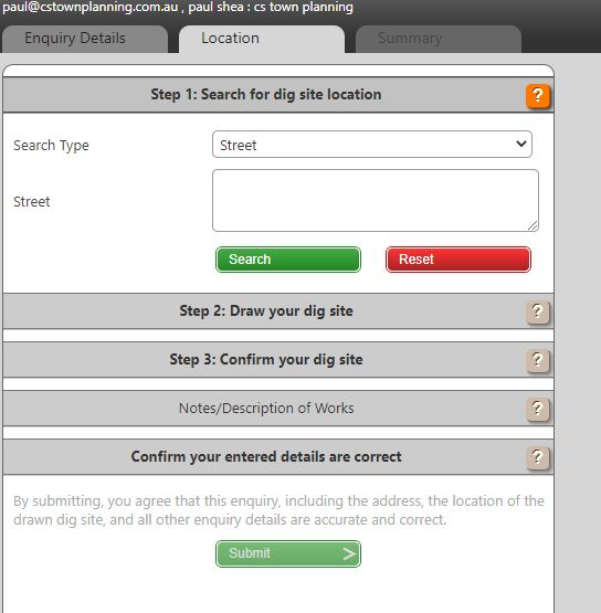
Type your street name into the empty field below and click search.

Click on the draw tool highlighted below in yellow and draw around your property boundary. Your outline does not need to exactly match your boundary for the findings to be accurate.

Click on the green submit button on the right hand side of the screen.
In the next screen you will see a table like the below image that outlines the authorities that have been notified of your request. Each of these authorities will send you a map and letter that discloses the location of any underground assets within or close to your site.

This information is very helpful to show you how the existing house on the land connects to sewer, water and electricity. It is also very helpful to identify where any existing underground pipes are that will need to be relocated and recounted during construction. The critical information within the maps is the location of the existing stormwater pipes and sewer pipe within the property. These pipes are the property of council and the sewer provider and these authorities have very strict rules about how close you can build to these pipes and what, if anything they will allow to be built over the pipes. Very often these pipes are within a designated ‘easement’ on the land such as pictured below but they are not always.

The dial before you dig information also contains information that includes the size of the pipe and how far away from the nearest boundary it is. This information isn’t available in a section 32 or from looking at a property title and the plan of subdivision of the lot. For assistance in understanding any of the information about your property within these maps please contact our office and we would be happy to help.
3. Check the property title for covenants or restrictions
Very often property titles will include a restriction to prohibit the future subdivision of a lot. Where such a restriction exists it is easy to identify on certificate of title that comes along with a section 32.
The image below identifies where on the certificate a restriction appear.

If there is a covenant or restriction registered on the certificate of title it is important you read the restriction in full and if required contact an expert to assist in its interpretation. Any mortgages on the property will also appear in this section of title certificate however these will have no bearing on whether or not the property can be subdivided. If there is a restriction or a covenant registered on the property that prohibits subdivision on your land then it will be necessary to vary this restriction as part of the application for a planning permit to council. This adds complexity to your application as it allows any of the designated beneficiaries of the restriction the ability to prevent a subdivision being approved. If you have any restrictions registered on your title please provide a copy to our office to review prior to commencing a subdivision project.
